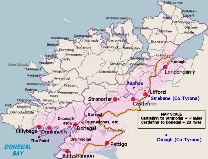
| The Crawfords lived in the diagonal band running NE-SW (shaded pale purple). Their main concentration was along the coast on both sides of Donegal Bay. Another concentration was some 15-30 miles North East near the border between Co.Donegal and Co.Tyrone at Stranorlar and Lifford. At the time of the plantation of Ulster, it was simply a county border, but it is now the border between Northern Ireland and the Republic of Ireland. A further married Crawford lived at Anagh (Enagh) in Co.Londonderry. At the time, the ports of Derry, Donegal and Killybegs were very active and traded with the ports of Glasgow, Stranraer, Ayr, Irwin, Greenock and Largs along the west coast of Scotland. For those who wish to find these locations on a more detailed map, the table below lists the main towns that are referred to in the "Crawfords of Donegal" pamphlet. Please read the notes below the table for further details. |
| Townland | Barony | Civil Parish | Map Ref | Latitude | Longitude |
| Anagh | Tirkeeran* | Clondermot | C 464 201 | 55° 01' 40" | 7° 16' 25" W |
| Ballyshannon | Tirhugh | Kilbarron | G 877 615 | 54° 30' 00" | 8° 11' 20" W |
| Castlefinn | Raphoe | Donaghmore | H 265 950 | 54° 48' 05" | 7° 35' 20" W |
| Donegal | Banagh | Killymard | G 931 787 | 54° 39' 20" | 8° 06' 30" W |
| Drumadoney | Tirhugh | Donegal | G 980 792 | 54° 39' 40" | 8° 02' 00" W |
| Drumark | Banagh | Killymard | G 905 787 | 54° 39' 10" | 8° 08' 25" W |
| Drumgun | Banagh | Killymard | G 904 780 | 54° 38' 50" | 8° 09' 10" W |
| Drumhome | Tirhugh | Drumhome | G 890 705 | 54° 34' 55" | 8° 10' 20" W |
| Drumkeegan | Banagh | Killymard | G 900 795 | 54° 39' 40" | 8° 09' 15" W |
| Dunkineely | Banagh | Killaghtee | G 765 760 | 54° 37' 50" | 8° 21' 40" W |
| Finnadoos | Tirhugh | Donegal | G 984 799 | 54° 40' 05" | 8° 01' 35" W |
| Garvagh | Tirhugh | Donegal | G 980 844 | 54° 42' 40" | 8° 01' 40" W |
| Gortinessy | Tirhugh | Templecarn | H 116 692 | 54° 34' 10" | 7° 49' 15" W |
| Gregstown | Tirhugh | Donegal | G 958 741 | 54° 36' 50" | 8° 04' 00" W |
| Killybegs | Banagh | Killybegs Upper | G 712 764 | 54° 38' 10" | 8° 26' 40" W |
| Leghawny | Tirhugh | Donegal | G 998 797 | 54° 39' 55" | 8° 00' 10" W |
| Lifford | Raphoe | Clonleigh | H 333 984 | 54° 49' 50" | 7° 29' 00" W |
| Liskeran | Raphoe | Stranorlar | H 135 993 | 54° 50' 30" | 7° 47' 25" W |
| Londonderry | NW Liberties* | Templemore | C 434 167 | 54° 59' 50" | 7° 19' 00" W |
| Meenadreen | Tirhugh | Donegal | H 016 789 | 54° 39' 30" | 7° 58' 25" W |
| Omagh | Omagh East* | Drumragh | H 458 727 | 54° 36' 00" | 7° 18' 00" W |
| Pettigo(e) | Tirhugh | Templecarn | H 110 668 | 54° 32' 55" | 7° 49' 40" W |
| Point, The | Banagh | Killaghtee | G 712 701 | 54° 34' 40" | 8° 26' 30" W |
| Shannon | Raphoe | Clonleigh | H 284 987 | 54° 50' 10" | 7° 33' 30" W |
| Stranorlar | Raphoe | Stranorlar | H 147 950 | 54° 48' 00" | 7° 46' 30" W |
| Tully | Tirhugh | Donegal | G 948 777 | 54° 38' 45" | 8° 04' 55" W |